Anthony Robin, local Speedwatch volunteer for West Bergholt & Eight Ash Green, is passionate about the need for drivers to cut speeding, but in making his regular report and call for volunteers, his thoughts wandered into some historic and other directions related to speed. The following is the result of this little distraction:
When I came to live in Eight Ash Green, over 30 years ago, the main road through the village was called the A604. The large green route signs labelled it as so, with the destination Cambridge marked, and if I remember correctly, the distance given was 49 miles. Originally the A604 had run all the way from Harwich to Kettering. In fact the 6 at the front suggests it does not belong to this sector of the country, but the sector between the A6 (London-Holyhead) and the A1 (London-Edinburgh). Our sector roads start with a one.
To try to reduce the through traffic the authorities, relabelled the road, and whilst the route still exists it has different numbers for different sections. Our local section, between Colchester and Halstead is labelled A1124, the next section to Haverhill is A1017, and the section between Haverhill and Cambridge is A1307. The through traffic is signposted either A12 & A14 via Ipswich, or A120 and M11 via Stanstead.
Nevertheless this route is a lot shorter, and so for slow traffic is quicker, so many lorries still use this route. In fact my SatNav suggests I use the ‘A604’ route to get to Addenbrookes Hospital, and the A120/M11 route to Cambridge centre. The authorities also changed the speed limit through all the villages on our route from 40 to 30 mph.
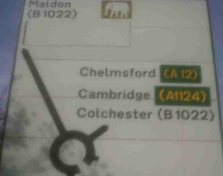
Despite these changes, a few months ago, I noticed that one sign on the “South Circular” between Kent Blaxill and the Leather Bottle was still directing traffic to Cambridge along this route (see picture above). It was misleading, because there are no follow on signs for Cambridge.
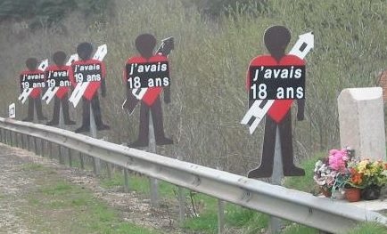
The A1307 section is in Cambridgeshire, and there are large notices saying that the route is dangerous, saying high speed collisions kill and asking motorists to slow down. There are also several “graves” on this section of the road. No one is actually buried there, of course, but there are flowers and gravestones and even pictures of people who have been killed nearby.
In France it is official policy to put signs up as shown right, although the actual style varies in the different Departments. This particular one shows where 5 teenagers were killed. It certainly pulls no punches! Should we be doing this in the UK? Does it make people realise the dangers of the roads, or does it even distract motorists making other accidents more likely?
To try to make local motorists obey the speed limit in our villages, both on the A 1124, B 1508 and elsewhere, a few of us regularly go out with a radar gun, and report offenders to the police. The project is called Speedwatch, and other groups go out in other parts of the County. Other Counties are involved with similar schemes.
If you would be interested in joining us, please contact me.
Anthony C Robin 01206 571910, [antibot mailto=”[email protected]”]
Postscript
This news update was posted to our Facebook page where a reader provided this further insight into the politics of road naming:
At the time of the route re numbering I was a member of Castle Hedingham Parish Council. ECC proposed that the road from Braintree Corner, Sible Hedingham, and Halstead High Street be downgraded to B road status (in order to further reduce the chances of drivers seeing the old A604 as a viable through road). There were various objections (you can probably guess from whom) on the grounds that if Halstead were no longer a crossroads of two A roads it would lose some of it’s status. This from people who continue to campaign for measures to reduce traffic through Halstead…. Simon Daw