West Bergholt History Walk #2
 This walk was originally published by B Skudder & D Fulford of the Local History Group in May 1987 so some of the village scene has changed but the walk is still valid and most (if not all?) of the buildings still in place.
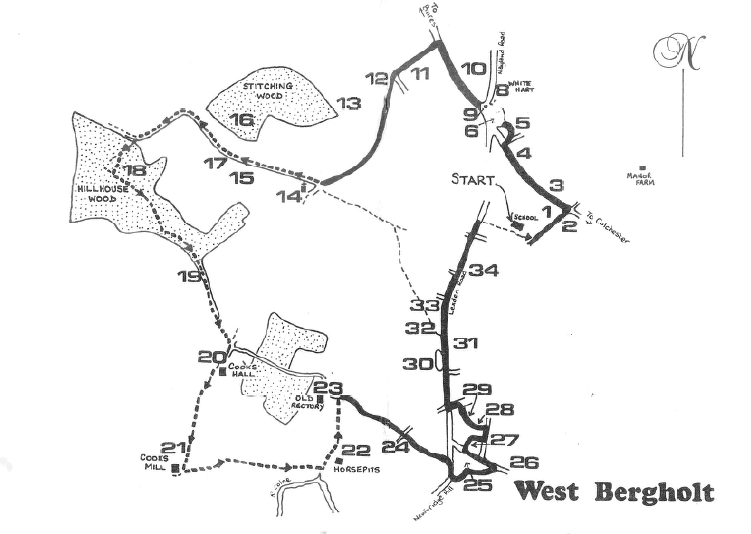
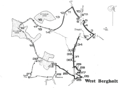
There is a larger image of the route at the end of this article.
If you would rather use a printed copy then please download the following PDF file – it will squeeze onto 3 pages if printed double-sided.
Introduction
Welcome to the second walk around West Bergholt – the village on the ‘wooded hill’. With the passing of the Brewery, West Bergholt now seems set to become a dormitory village for Colchester, and to the casual viewer offers little in the way of historical interest. This walk is planned to give some insight into the area and the events that have shaped its present form.
The walk is approximately 4 miles long, although for those unable to tackle the woodland paths, there is a shorter route indicated. Leave the path at No. 14 by the Old Church, cross to Lexden Road to No. 32, walk down to Newbridge Hill and pick up the walk at No. 25.
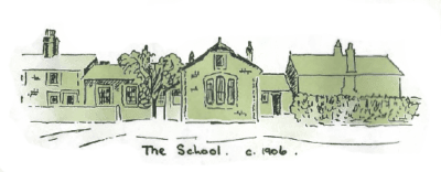
You are starting your walk from the Heathlands School, opened in 1858. There have been several alterations and extensions which have reflected the needs of the village, and now only one small part of the original buildings remains.
The area surrounding the school is the last remaining part of the Heath which used to cover an area of over 312 acres. The Heath was owned by the Lord of the Manor and the villagers used to be allowed to graze their animals and collect furze.
In the 1840s, the Heath was the centre of interest, following an outbreak of incendiarism (fire-raising), as poorly paid farm labourers protested against agricultural mechanisation. The village itself was heavily hit with over 9 farms attacked by the fire-raisers, and on the Heath was found a note stating ‘Give us work or we will make fires.’ Eventually, a local man was tried and convicted of arson and was transported for life.
Follow the footpath past the School and turn left at the end, into School Lane
1. The Common Garden
This area, originally 5 acres, was ‘to let to any poor and industrious inhabitant’ after an Act of 1793 was passed for the Relief and Employment of the Poor. Ten rods were laid down as the amount of land that a man could cultivate without detriment to his daily work – and this measurement is still in use today.
2. The Treble Tile
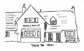 Once a cottage used as a beerhouse, these premises have undergone many alterations. The name ‘Treble Tile’ is said to come from the three waves in the pattern of a roofing tile made locally, at a kiln once located behind Manor Farm. The inn and many of the buildings in the area had these tiles.
Cross over the road and continue walking left along the footpath.
3. No. 32, Colchester Road
This was once a butcher’s shop belonging to Mr. Oscar King from the late 1920s. The business was bought up and amalgamated with Elmer’s (Londis) in Chapel Road in 1950.
If you look at the view through the gap in the hedge (opposite The Bays), you will see what used to be the northern part of the Heathland. This land was enclosed in 1865 and much of it became part of the (then new) Manor Farm.
4. Brown’s Shop
At the beginning of this century, this was the Post Office run by the Claydon family. The first Post Office was further back down the Colchester Road, in the cottages which are part of the Miller Motor Group Sales premises.
Turn right into The Crescent.
 5. The Crescent
 5. The Crescent
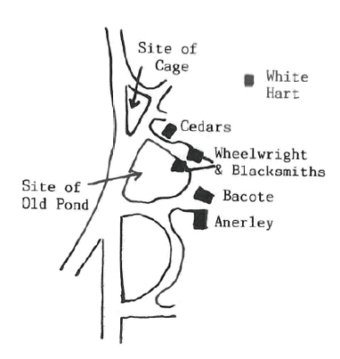
This area is one of the oldest in terms of settlement and industry. It grew up around the White Hart and the pond and became a natural stopping place for travellers.
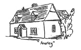
Anerley
In the middle of the nineteenth century, this was one of three properties in the area mentioned as belonging to Bailey Pittock, a blacksmith, wheelwright, grocer and brewer. It was formerly known as ‘The Crown and Sceptre’ Brewery.
To the left of this cottage is
Bacote
This was once the Bake House run by the Claydon family. It is believed that this was the building mentioned in the early nineteenth century as having a large room adjoining it at the back, which was used as a Chapel.
Follow the Crescent round to the right, and walk along the path in front of MacNally’s Yard.
6. Site Of Village Pond
Until the 1950s, when it was filled in, one of the three Public Ponds designated by the Enclosure Commissioners in 1865, lay on the site of this building yard.
If you look to your right you will see down the yard entrance,
7. The Wheelwright’s & Blacksmith’s Shops.
The wheelwright’s was used until the late 1940s, and both premises depended upon their trade from the farmers and the travellers who stopped at the White Hart
On your right is
The Cedars
This was the home of Mr. A. E. Partridge who was the village undertaker and wheelwright. He used the premises in the Crescent for his business.
Cross over the road to the triangle in the centre of the road junction. If you look back, you will see
8. The White Hart
This inn has probably been in existence for centuries, but is first recorded in the records in 1760. It used to be a popular stopping place for farmers taking sheep and cattle to market.
9. The Cage
You are standing where the Village Cage or ‘lock-up’ used to be located, in the days before the Police were established. It is recorded as being arched over in brick with a door and a hole for ventilation on the south side. It was used for holding people overnight to ‘sober up ‘ or to await transport to the courts in Colchester. It was demolished about 1870
Cross over the road and continue along the footpath on the road to Bures.
10. White Hart Field/ Heath Field
Originally two fields rented by Thomas Daniells of Brewery fame, in the 1840s. Heath field probably called such because it was once situated on the edge of the Heathland.
Cross over the road into Hall Lane.
11. Gibbs Field
12. Rockall
On this site were a pair of cottages tenanted by Mr. Pettican, the village shoe-maker, and Mr. Oscar Alston Jnr. This was in the 1930s.
13. Great Botts
This field name may be a corrupt form of ‘butts ‘ and could have been an area used for archery practice.· Another meaning for ‘butts’ is connected with the short strips in the common fields which abutted adjacent lands more or less at right angles. There is a Little Botts field and a Butt Snips field nearby.
Continue down the lane, turning right by the Old Church, and walk along the footpath towards Fordham. Notice the old fingerpost.
14. St. Mary ‘S Old Church
In 1986, a wall-painting above the chancel arch was restored. It depicts the Royal Coat of Arms of James I, dating back to 1603. As you walk past the north wall, look out for the remains of the arch near the window nearest the bell tower. This has enabled the Church to be dated to pre-Norman conquest times. Further details about the Church are given in the Walk No. 1 booklet.
15. Kiln Field
One of several Kiln fields in the parish, signifying the brick and tile industry.
16. Stitching Wood
This is one of several woods in the eastern part of the parish that belonged to the Lord of the Manor of Bergholt Sackville. The trees on the edge show the practice of pollarding. They were cut regularly at about 6 feet above ground level to provide a supply of poles. The hurdle-maker used to rent this wood in the mid-nineteenth century.
 17. Site of the Hurdle-Maker’s Cottage
 17. Site of the Hurdle-Maker’s Cottage
The area of bramble on your left marks the site of the cottage that used~ to stand here, and which, in the 1840s was rented, along with the woods, by the hurdle-maker.
Continue walking along the track, following it round to the left. You are now approaching
18. Hillhouse Wood
Known locally as ‘Halus Wood’, this probably owes its name to Geoffrey atte Hull (1272). In 1585, it was known as Helhouse Grove, and has always belonged to the Lord of the Manor.
Enter the wood through an old gateway, When the path splits, take the left fork, continue until you reach crosspaths, turn left and continue walking along this well-trodden track until you reach the outskirts of the wood on the other side . Depending upon the time of year, you may see bluebells, celandine, wood anemones and rhododendrons.
19. Old Track
As you cross over the stile, notice to your right the sunken remains of old track or footpath – a ‘green lane’.
Keep to the right hand side of the field and walk to the end where you will meet with the Essex Way. Turn right and follow the signed footpath between the farm buildings. You are now within the boundaries of Cooks Hall Farm.
 20. Cooks Hall and Farm
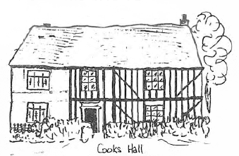 20. Cooks Hall and Farm
Once known as Beaumonds from a John de Beaumond who rented the lands in 1272, this became a manor in the 15th century. It is also known as Netherhall, probably because it is in the lower part of the parish. Parts of the building date back to the 16th century and there appears to be the remains of a moat around the building.
There used to be a double-seater privy here, with the inscription, ‘If you want to keep this chapel sweet, Open the door and close the seat.’ This was dated 1822 and signed by T. Lungley
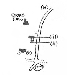 As you walk through the farm yard you will pass, on your left, a large barn (i). This was hit by bombs during the Second World War and, in fact, what you see, is only the half remaining. Further down on the left are the ‘pig courts’ (ii), and next to them, what is believed to be the pound (iii) where stray cattle and horses used to be kept. Again on your left further down past the house, you can see an old brick wall clearly showing both medieval and modern size bricks (iv).
Continue walking across Mill Field. On your right, you will see the large barn and rear of Cooks Mill House.
21. Cooks Mill
The mills used to be used in the cloth trade in West Bergholt from the 13th century. They were fulling mills and used the waters of the River Colne to clean the cloth. The house itself is all that remains, and dates from 1724, but the Mill Race can still be traced in the gardens.
Turn left at the white gate and walk across the field towards a large solitary tree, then continue in the same direction along the field boundary. To your right are the meadows used extensively in earlier times for grazing sheep, and beyond them, the parish boundary of the River Colne. Straight ahead is ….
22. Horsepits
This building dates back to the early 16th century and contains a wall painting on a religious theme. The outer shed was used for brewing and for many years it was owned by the owners of Newbridge Mill. In the Second World War a small chamber was found and an inscription on the wall had the date 10th November, 1628 and the initials D.T.S.
Turn left, keeping the hedge and premises of Horsepits on your right, and walk up the hill, over a stile and cross the field, bearing slightly to the left to a second stile. Go over the stile and you will be crossing the grounds and entrance drive of the
23. Old Rectory
A Sunday school was started here in 1817, by the Reverend Sims. Despite strenuous efforts he was unable to see his ambition of establishing a Church School in the village. He died in 1846 and is buried in the Old Church Graveyard.
Cross the grounds of the Rectory to a gap in the hedge to the left of a holly bush and walk out onto the lane. Turn right and continue walking to the crossroads near the Gas Sub-Station.
24. Site of Cottage
To your right, on the left side of the private road leading to Horsepits, you will see a triangular area of brambles and scrub. This is the site of ‘a brick cottage with a large garden. When the premises were sold in 1906, the tenant, Widow Butcher, claimed the copper as hers’.
Continue straight on to the junction with Newbridge Hill. Cross over and turn right and sharp left into Whitehouse Lane – this is the southern limit of the original heathland.
25. Sandy
This house used to be called Bravo Villa and was built by one of the Diss brothers who were local builders. Alfred Diss was responsible for the building of the Chapel and several houses in the area. It is believed that he also built the small ‘Gothic’ type cottages which can be seen in this area; an example is next door to Sandy. These date back to about the 1880s.
Stop at the end of Whitehouse Lane.
26. Meadow Land and Windmill
The area to your right was once meadowland, where the Chapel fetes used to be held. Further along towards Chapel Lane it is believed was the site of a windmill.
Turn left past Queens Road, and turn right after ‘Brownleigh’ into a narrow gravelled lane. On your right is a house called
27. The Hollies
Mr. Walter Garling lived here and was the local baker.
Turn left into Queens Road. Opposite the entrance to The Avenue used to stand two old mud cottages of the type known locally as ‘mangel clamps ‘ because of their resemblance to the clamps made by the farmers for their root crops. There were several of these cottages in this area, many surviving until earlier this century.
28. Sweet and Tea Shop
As you turn left into the Avenue, the cottage on the far corner used to be a sweet shop. The little room added on at the back used to be a tea room.
29. The Ramblers
This was the home and premises of the Allston family. They used to sell milk.
At the end of the road, turn left, cross the road and turn right at the junction with Lexden Road. Continue walking up Lexden Road. On your left, next to ‘High Meadows’ is
30. Lexden Road Pond
This was one of the three Public Ponds established by the Enclosure Commissioners in 1865.
 Sackville Cottage
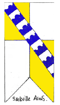 Sackville Cottage
Situated behind the Lexden Pond, this cottage takes its name from the Norman family who were Lords of the Manor for over 300 years. The village itself used to be known as Bergholt Sackville.
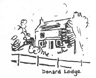
31. Site of Donard Lodge (Dairy Farm or Ardens )
In the garden of No. 79 you will see a large tree which used to stand in front of an old 18th century farmhouse known as Donard Lodge. In the 1720s it was called Ardens later becoming Dairy Farm, owned by the Bradbrook family for over 100 years. In the 1840s the farm was the only building within the Lexden Road, New Church Road and Chapel Lane triangle.
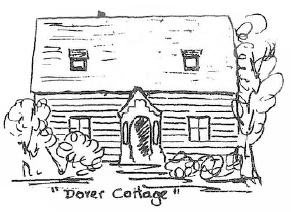
32. Dover Cottage
Until a few years ago, a cottage stood to the right of the footpath and stile leading from the Old Church. It was a weather-boarded cottage and in the 16th century was known by the name of ‘Dovres’ or ‘Dobers’.
Further along, on the left you can see at No. 86
33. The Old Police House
You are now approaching, on the right,
34. The Lorkin Daniell Recreation Field & the Orpen Memorial Hall.
Both Mr 0. G. Orpen and Mr. Thomas Lorkin Daniell were managing directors of Daniell & Sons Ltd, Brewery, before the Second World War. When Mr, Orpen died in 1917, he left a bequest to the Parish to build the Hall. Mr. Lorkin Daniell gave the land and the recreation field. The Hall was completed in 1938 and was recently extended.
Cross New Church Road and continue past the new Scout H.Q., turning right at the footpath sign, back onto the Heath.